
The 350th Anniversary of the Quaboag Plantation 1660-2010
As part of the 350th celebration of the settlement of the Quaboag Plantation, the town of New Braintree’s 350th Anniversary Committee held a series of Wheeler’s Surprise events. This included a reenactment of the ambush, a reenactors camp site, a video tour of the three possible locations of the battle, and a talk by Robert W. Wilder on the ambush. The Society of the 17th Century, a group that demonstrated period crafts, clothing and hand-on activities were camping at the town center. That evening at town hall was a dinner, cash bar, silent auction, and a talk on King Philip’s War by the author Michael Tougias; “Wheeler’s Surprise Event.”

Michael Tougias
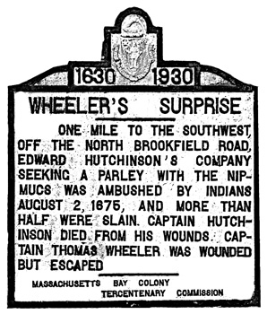
1930 Wheeler’s Surprise Road Sign
This program was supported in part by a grant from the New Braintree Cultural Council, a local agency which is supported by the Massachusetts Cultural Council, a state agency.
Wheeler’s Surprise site artifacts donation
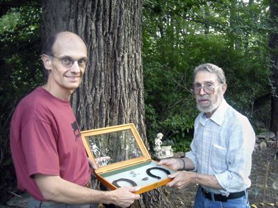
Society President, Tom Fiorelli (left) accepts Wheeler’s Surprise site artifacts of two horse shoes, three musket balls, and a buckle as donated by Bob Wilder. Photo by Joe Salvadore.
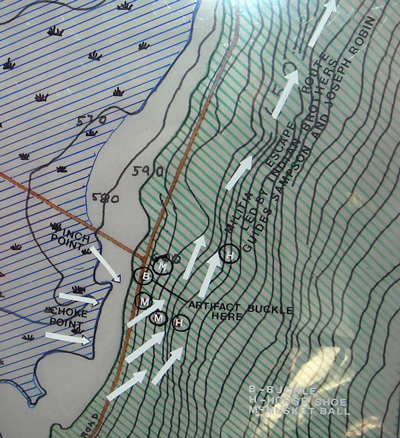
This map shows the locations where these items were found
B-Buckle
H-Horseshoe
M-Musket ball
Arrows-Escape route
History of New Braintree – Jeffrey H. Fiske
Before its settlement by the English, New Braintree appears to have been continuously occupied by various groups of Native Americans for at least 9,000 years. Major village sites are found along the valley of the Ware River and beside the larger streams that run through the town. There are also many minor camp sites found on the smaller brooks in the uplands. The town has long been a popular spot for collectors of Indian artifacts, and stone tools from all periods of native occupation have been recovered from its fields
The last group of Indians that made New Braintree their home were the Nipmuck or Nipnet Indians. The name is said to mean fresh water or fresh water fishing place.This loose confederation of tribes occupied Worcester County and lands westward toward the Connecticut River Valley and from the New Hampshire border southward into northern Connecticut
The Quaboag Indians are often given status as a separate tribal group. These Indians were centered about the natural lakes in the Brookfields, and their domain would certainly have extended into New Braintree. However, with the start of King Philip’s War the several tribal groups in Worcester County seem to have lost their identity as Quaboags, Waushacums, Nashaways, etc., suggesting that perhaps the term Nipmuck may be applied to them all.
Wheeler’s Surprise:
Wheeler’s Surprise was the ambush of an expedition sent out by the colony of Massachusetts to gain the neutrality of the Nipmuck Indians during King Philip’s War. The ambush took place August 2, 1675, apparently in the swamp land that is found along Winimusset Brook in New Braintree. The English were under the command of Captain Edward Hutchinson who had an escort of about twenty horsemen led by Captain Thomas Wheeler. Ephraim Curtis and three Indians friendly to the English accompanied Hutchinson as guides and interpreters. Three men from Quaboag Plantation or Brookfield were also with the expedition
The name Wheeler’s Surprise has been attached to the ambush because Captain Thomas Wheeler wrote a detailed account of the attack and the subsequent assault on the town of Brookfield
With the start of King Philip’s War, it was hoped that the conflict could be limited to Philip and his tribe, the Wampanoags. To this end Ephraim Curtis was sent into Nipmuck Country in July to determine the intentions and temper of the Indians. Curtis found that the Nipmucks had deserted their traditional village sites and had settled on an island in a swamp within two or three miles of the lead mines in Sturbridge, Massachusetts. Although initially hostile toward him, the Indians appeared well appeased; when he left.
After making his report in Boston, Curtis was sent back a second time and found the Indians on the same island. The Nipmucks seemed much more inclined toward peace and promised to send emissaries to Boston. Becoming impatient, the Governor and Council of Massachusetts sent Hutchinson and Wheeler back with Curtis to secure a firm pledge of neutrality from the Nipmucks. The expedition returned to the island near the lead mines in Sturbridge, but the Indians were gone. Turning south they searched for the Nipmucks as far as Norwich, Connecticut before turning north to Brookfield. Upon arriving at Brookfield, now West Brookfield, they were told that the Indians were ten miles to the northwest
Ephraim Curtis and three other men were sent to find the Indians and arrange a parley. Curtis reports that he found the Nipmucks in a swamp eight miles north of Brookfield, probably at the village site on the plateau that extends northeast from the Perez Cobb, or North Cemetery, in New Braintree. A meeting was arranged for the following morning at eight o’clock on a plain three miles north of West Brookfield
The next morning, August 2, Hutchinson and his party waited in vain for the Indians to arrive. At the urging of the three Brookfield men with them, and against the advice of the friendly Indians with the expedition, the party moved north toward the swamp where the Indians were located. Upon approaching the swamp, the English were forced to move in single file due to swamp land on their left and a steep hill on their right. After proceeding in this way for 300 to 400 yards the expedition was suddenly raked with musket fire from a well-laid ambush
Unable to move forward, the English turned to retrace their steps only to find the way they had come blocked by the Indians. With swamp to their left, their only escape was up the steep hill to their right. Spurring their mounts up the hillside, the troopers managed to escape the deadly fire of the Nipmucks
Behind lay eight dead or dying Englishmen, including the three Brookfield men who had urged the expedition forward. Of those still in the saddle, several were badly wounded, including Thomas Wheeler and the leader of the expedition, Captain Edward Hutchinson. The survivors made a frantic retreat back to Brookfield, guided by their Indian interpreters. Upon arriving at Brookfield, they warned the inhabitants who gathered together in the Ayres Tavern. The Nipmucks followed and attacked the garrison. The siege lasted until August 4, when the arrival of Major Simon Willard and his mounted troops caused the Nipmucks to withdraw.
Three sites, all located in New Braintree, have been offered as possible locations of the ambush. Josiah Temple in his History of North Brookfield locates the ambush on Mill Brook just over the line from West Brookfield. Lucius R. Paige, author of the History of Hardwick, puts the ambush site in the valley of the Winimusset Brook, but Dr. Louis E. Roy in his book Quaboag Plantation Alias Brookefeild places the ambush site on the west side of the hill that is found north of the junction of Padre and West Roads
Paige’s Winimusset Valley site seems to be the correct location. (For a detailed discussion of the ambush, see Wheeler’s Surprise, The Lost Battlefield of King Philip’s War by Jeffrey H. Fiske.) Whichever site is correct, all three locations are within the present borders of the town of New Braintree. At the annual town meeting in March of 1905, the town appropriated fifty dollars for the erection of stone monuments to show the location of Wheeler’s Surprise and King Philip’s camp (Menameset) on the Ware River.
The following year, on November 1, 1906, a marker was erected designating the location of Wheeler’s Surprise on what is today Slein Road, near the point where the road turns west across Winimusset Brook and up the hill to West Road. The stone read, “Somewhere within a half mile, along the base of this hill, Capt. Edward Hutchinson, and his company, were attacked by Indians, lying in ambush, Aug. 2, 1675, and he and more than one half his men, slain or wounded”. C.A. Risley of West Brookfield supplied and cut the stone and directed its erection. The location of the marker was determined by a committee composed of town historian George K. Tufts, the Rev. W.W. Wakeman, and J.E. Barr.
When Slein Road from Winimusset Brook to West Road was discontinued (after the bridge over Winimusset Brook was washed out during the flood of 1955), the stone was moved out of the valley to West Road where it stands today. It appears that the monument on Hardwick Road just east of Winimusset Brook, which reads “Site of King Philip’s Camp, August 1675”, was erected later, in June of 1907.